
No Straight Lines
- Donna Hanson

- Mar 12, 2024
- 3 min read
Updated: Mar 12, 2024
I'm going on a road trip.
Even though I've never been one to put off anything, it's easy enough to become complacent in the routine of things. When I was young, free time meant reading a book, taking a walk, or listening to a record in a candle-lit room before dozing off to sleep. I had precious little money, but when I was able to scrape together a couple of twentys, it was time for a road trip.
Planning a trip took just that...planning. Route choices came from road maps published by local and regional news sources, drug stores, petroleum companies, and insurance companies. Things didn't change much in the early 1970s, when I first started driving, so a good road map could last a decade.
More than just lines on a page, road maps contain quite a bit of useful information such as mileage charts which provide distances between major cities. In the case of the trip I'm planning, I see that it's 264 miles between Needles (one of my stops) and Los Angeles (another stop). That's a magic number as it's the most time I plan to drive in a day (basically, 5 hours) and it's the most I can ask of my gas tank.
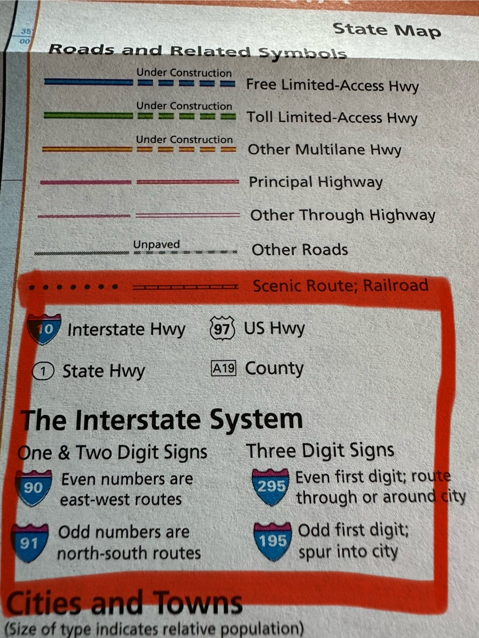
We navigated by reading the mile markers along the highway. Mile markers begin at the state line, and increase from south to north for north-south highways. Here's a fun fact: highways running from west to east typically have one or two numbers, and are odd. The lowest numbered routes are in the south. Likewise, highways that run north to south are evenly numbered with the lowest numbers in the west. An example is California highway 1 which is a north/south route along the coast which begins in Dana Point, about an hour south of LA, and terminates into US 101 near Leggett in Mendocino County, a couple hundred miles north of San Francisco.
One of my stops along this planned trip is Malibu Lagoon State Beach. The last time I made this trip was in 1975 with a girlfriend. We drove with a highway map folded to the applicable section, and used a pencil to mark our progress along the route. If we wanted to arrive at the beach before lunch, we'd plan for 9:30 am to avoid the morning surfer crowd and sun worshipers in the hopes of finding a parking spot. In those days, it wasn't difficult to find a spot, especially during the work week. I have a feeling that times have changed.
I've been using an app called "The Dyrt." I've inserted a hyperlink if you want to check out the app which I've found useful, but not the end-all be-all. I still use road maps for one very good reason: there are no straight lines. Unless you're flying an airplane (and even then, rarely do you ever "go direct" to your destination) the US highway system is full of surprises. Let's look at some sections from this 2004 issue of Rand McNally's map of California.
Here's a rough sketch of my planned trip. At this stage, nothing is cast in stone, these are just some places I might like to see.

There are a couple of waypoints that will need further investigation (like crossing the Rockies in my 24-year old camper van), but today, let's look at the best way to get to California. I had planned on taking a northern route through Needles as I mentioned above, but looking at the road map, I may choose to take Arizona 95 to Parker (and stop in beautiful Lake Havasu), then take California 62 and circle Joshua Tree (another beautiful place). There are a handful of campsites in the park. I would want to ensure I filled my water tank in Twentynine Palms just in case.
If you zoom in, you can see that California highway 62 is designated as a scenic byway with gas stops along the way. It's 15 miles from Twentynine Palms to Sunfair, 7 to highway 248, and then 3 to Yucca Valley where there's also an information center (indicated by the black square with a white question mark. And from there I could continue 19 miles to I-10 (also a scenic route) through San Bernadino, to the 210, to 101 to the N1. Not a horrible route. Or...
I could stick with plan A and take I-40 to Barstow and take I-15 though Apple Valley...might just stick with that. I haven't been to the San Bernadino National Forest or Big Bear Lake since high school.
No bad choices and...no straight lines.


I miss having real maps folded in my door pocket, under the visor, in the glove box. It was while trying to read a map somewhere on the road from NWA to NY in 2009 that I found out I needed reading glasses, lol. It was part of the fun to stop at every state line to collect a new map, too. Have fun on your trip! It looks like a fabulous one.
Thank you the the link ~ love your planning! Can’t wait ~ I’m so looking forward to coming” along with you on your Sunrise Road Trip!